Work package: Archaeological investigations in respect to the origin and development of oasis settlements in Oman
Contact Person: Dr. Jutta Häser, German Protestant Institute of Archaeology, Amman
Scientific staff and PhD students: Dr. Jutta Häser, Dr. Muhammad al-Balushi, Nasser al-Hinai, Dr. Jürgen Schreiber, Dipl.-Ing. Angelika Schulz
Objectives: The research is focused on processes of transformation throughout history, regarding the architecture and material culture, the economy and ecology of the oasis settlements in a regional and interdisciplinary approach. The aim of the archaeological study is the investigation of the settlement in respect to their establishment and development as well as their ecological setting.
Study locations:
Archaeological survey at Wadi Bani ‘Awf and the oasis al--Hamra
Objectives: The research is focused on processes of transformation throughout history, regarding the architecture and material culture, the economy and ecology of the oasis settlements in a regional and interdisciplinary approach. The aim of the archaeological study is the investigation of the settlement in respect to their establishment and development as well as their ecological setting.
Research history: In 1999 the region of the Wadi Bani ‘Awf (approx. 120 southwest of the capital city Muscat) on the northern side of the al-Hajar mountains as well as the oasis al-Hamra south of the al-Hajar mountains were chosen for testing the possibilities of the archaeological conditions and the methodology. Four campaigns were carried out in 1999 and 2000. A ground check of the results was undertaken in 2001.
Methodology: Different methods were used in the study of the archaeological sites. The survey was prepared with the help of aerial photographs scaled 1:20,000, which were examined in respect to archaeological remains. They were also used in addition to a Global Positioning System (GPS) as a basis for mapping, since the existing topographical map scaled 1:100,000 was not exact enough to map the archaeological remains accurately. The aerial photographs were set in a mosaic for this purpose.
Pottery was collected from different archaeological sites during the survey. The sherds were determined in respect to ware, shape and date and statistically processed in a database. Not only prehistoric pottery sherds were registered, but also Islamic material, since this was generally almost neglected in previous research projects. In 2006 and 2007 the pottery was analysed scientifically and compared with material from other archaeological sites of the survey area. The investigations are in progress.
Architectural remains at selected sites were recorded using large-scale aerial photographs that were taken from a helium-balloon at a height of 300-1000 m above the ground. This work was carried out by the team of agriculturalists directed by Prof. Bürkert. The photographs were made with a normal camera. The ground plan of the buildings was drawn with the help of these images, which had been previously rectified. Afterwards the plans were controlled on the ground.
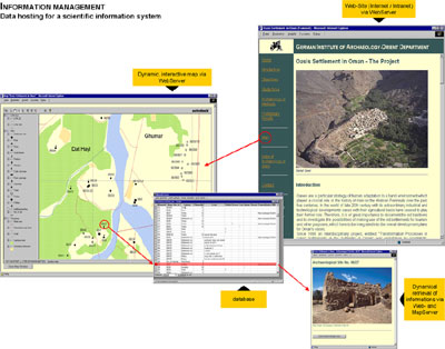
During the investigations outlined above, the first archaeological Internet-Geoinformationsystem was prepared to support both publication and dissemination of this documentation, not only for the scientists involved in the project but also for the broader public (Häser – Schulz 2004)l. Building an overall structuring frame, the website includes different parts of documentation, e. g., a general project outline, a map, an index of archaeological sites or contact information.
Information Management: data hosting for a scientific information system © 2003 Schulz
The digital map serves as an orientation base and includes the underlying spatial structure (e. g., surface topography, road and path network, land use) as well as archaeological sites. Further explanatory material such as text documents or photographs are referenced via incorporated hyperlinks (visualized as site number and/or cartographic signatures).
In absence of an appropriate map of the survey area, coloured aerial photographs (scale of 1:20,000, taken in 1985) were used for digitization. Following a graphic rectification, the clearly visible settlement areas, the road and path network and the drainage system were digitized. All relevant data associated with archaeological sites, such as geographic coordinates and further information regarding type and date, are stored in a relational data base. Now, according to user requirements each layer can be switched on or off. If a layer is configured as a dynamic layer, each request will initiate an update based on the current state of the connected data base. Different zoom levels and navigation tools allow selective views showing either an overview or details. Further tools are available to calculate area sizes or distances. Buffers can be created to define specific catchment areas, for example, to determine the range within tombs are located around settlements. These buffers can be saved automatically on a separate layer for further analysis. Additional information such as site descriptions, charts and photographs are incorporated in the dynamic map.
Results: Occupation of the region under study started during the early Bronze Age around 3000 B.C. It probably served as grounds for grazing. No settlements were found, but burial tombs were discerned that can be dated to the 3rd and 2nd millennium B.C.
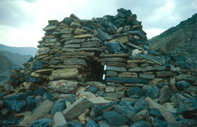
Hafit-type tomb of the 3rd millennium B.C. © 1999 Häser
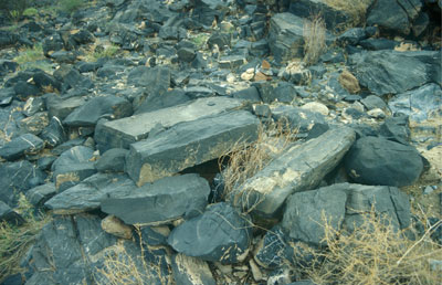
Underground tomb of the 2nd millennium B.C. or the Samad period (300 B.C.-900 A.D.) © 1999 Häser
The oldest settlement remains are evidenced from the early Iron Age period around 1000 B.C. Settlement activities were probably closely connected with the use of a new irrigation technology. Only this ‘falaj’-technologie made crop cultivation and planting of date palms possible in that region.
Settlement occupation was continuous since the early 1st millennium B.C. Diverse ecological conditions led to differences in the regional settlement development. While the settlements in the al-Hamra region shifted – probably due to shifting irrigation systems – the settlement occupation in Wadi Bani Awf remained in one particular place, i. e. Balad Seet, where an abundant and stable outflow of springs ensured a constant water.
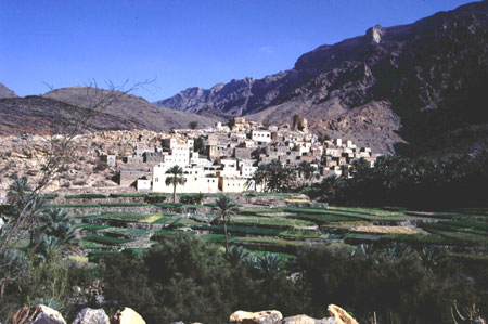
The oasis Balad Seet seen from south-east © 1999 Häser
A change in the occupational structure was enforced by investments of the new Ya‘ariba dynasty starting in the first half of the 17th century A.D. A new irrigation channel was built in al-Hamra, which made a shift in settlement to an area that was never occupied before.
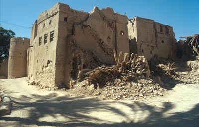
Large mud-brick house of the 18th century in al-Hamra © 2000 Häser
Some small oases settlements were also established in the Wadi Bani Awf during the same period, which met the requirements of newly built irrigation channels. It can be assumed, that these investments were also granted by the Ya‘ariba dynasty to encourage the tribes in that region.
Only with the oil boom since the 1970s has the settlement structure changed again due to modern roads, different construction techniques of houses, supply of electricity and use of water pumps.
Combining agriculture, hydro-infrastructural conditions and archaeological finds, a model of the settlement history of Balad Seet has been created (Nagieb - Siebert - Luedeling - Buerkert - Häser 2004).
Support
The archaeological project was financed by the German Institute of Archaeology, the Sultan Qaboos University Muscat and the German Research Foundation.
Publications
 |
Haeser, J. 2000. Jahresbericht 1999 der Orient-Abteilung: Feldforschungen in Oman, Archäologischer Anzeiger 2000 , 623–626, Berlin u. New York.
|
| |
Haeser, J. 2000. Formation and Transformation Processes of Oasis Settlements in the Sultanate of Oman: Preliminary Report on a new Field Project, Proceedings of the Seminar for Arabian Studies 30, 115–118, Belgium.
|
|
Haeser, J. 2001. Oman: Oase al Hamra. In: Deutsches Archäologisches Institut (Ed.), Stadtforschung: Projekte des DAI, 66-67, Berlin.
|
|
Haeser, J. 2002. Jahresbericht 2000 der Orient-Abteilung: Oman, Archäologischer Anzeiger 2001, 686–688, Berlin u. New York.
|
|
Haeser, J. 2002. Wadi Bani ‘Awf und Al Hamra Region (Oman), Jahresbericht 2001. Archäologischer Anzeiger 2002 2. Halbband, 200.
|
|
Haeser, J. 2003. Archaeological results of the 1999 and 2000 Survey Campaigns in the Wadi Bani 'Awf and in the al-Hamra-Region. Proceedings of the Seminar for Arabian Studies 33, 21-30.
|
|
Haeser, J. & Schulz A. 2004. An Internet-Geographical Information System for Multidisciplinary Research in Oman. In: Magistrat der Stadt Wien, Referat Kulturelles Erbe & Stadtarchäologie Wien (eds.), Enter the Past. The E-way into the Four Dimensions of Cultural Heritage. CAA 2003, Computer Applications and Quantitative Methods in Archaeology. Proceedings of the 31st Conference, Vienna, Austria, April 2003. BAR International Series 1227. 367-370.
|
|
Nagieb, M., Haeser, J., Siebert, S. Luedeling, E. & Bürkert, A. 2004. Settlement History of a Mountain Oasis in Northern Oman – Evidence from Land Use and Archaeological Studies Die Erde 135 (1), 81-106.
|
© Jutta Häser
|